|

Summer 2003 (11.2)
Pages
50-51
Mud Volcano Eruption
Lokbatan
- An Eyewitness Account in 1887
by Brita Asbrink
Mud volcanoes provide visible evidence above the surface
of the earth that oil and gas activity are occurring beneath
it. According to geological studies, more than 300 mud volcanos
exist in Azerbaijan, including some of the most active ones in
the world. Mud volcanos can even form on the floor of the Caspian
Sea.Occasionally, mud volcanos erupt with spectacular flames,
sending tons of mud flowing down the sides of the crater. No
doubt, such volcanic activity has been going on for thousands
of years. However, one of the earliest contemporary accounts
can be read in a Swedish newspaper, describing an eruption that
took place on January 5-6, 1887, at Lokbatan on the outskirts
of Baku. The description was provided by Swedish geologist Hjalmar
Sjögren, who was employed by the Nobel Brothers at the time.
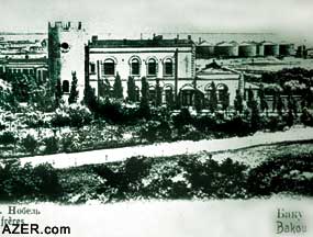
Below: (above left:) Petrolea, the residence
of the Nobel Brothers at the turn of the 20th century. The house
still stands today, though decrepit and empty. (Photos: Brita
Asbrink collection)
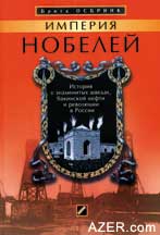
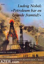
Right: (Above and below) Swedish documentary
writer Brita Asbrink recently published a book based on correspondence
between the Swedish personnel working with the Nobels in Baku
and relatives back home in Sweden. The book entitled: "Ludvig
Nobel: Petroleum Has a Bright Future"originally appeared
in Swedish (below) in 2001, and in 2003 was published in Russian
(above). Contact the author in Sweden to obtain copies: brita.asbrink@chello.se.
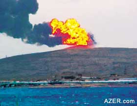
Below left: The latest eruption of the mud volcano
at Lokbatan, near Baku, took place on October 10, 2001, but it
seems that the volcano may have been erupting for centuries.
Geologists working for the Nobel Brothers described an eruption
that took place there in 1887. (Photo: Phil Hardy)
Robert Nobel (1829-1890), one
of the founders of the Nobel Brothers' Petroleum Company, was
the first entrepreneur in Baku ever to employ a geologist. He
brought him in from Germany. Obviously, this was a new scientific
endeavor as sceptics referred to him as "the Earth's crust
doctor". Over the years, the Nobels went on to employ numerous
geologists for their vast oil industry. They also set up a seismograph
to record the daily tremors of the earth's surface. Baku is located
within one of the world's active earthquake zones, which today
is known as the Alpine-Himalayan fault and stretches westwards
from Myanmar (Burma) to the Himalayas, across the Caucasus to
the Mediterranean.
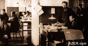  Left: At
the turn of the 20th century, Swedish Geologist Hjalmar Sjögren
worked for the Nobel Brothers in Balakhani near Baku. Maps were
studied and reports were written about the movements of the earth
crust, and all were sent to the Nobel headquarters in St. Petersburg. Left: At
the turn of the 20th century, Swedish Geologist Hjalmar Sjögren
worked for the Nobel Brothers in Balakhani near Baku. Maps were
studied and reports were written about the movements of the earth
crust, and all were sent to the Nobel headquarters in St. Petersburg.
In 1885, Ludvig Nobel
(1831-1888), Robert's younger brother, employed Swedish geologist
Hjalmar Sjögren, who was a professor in Mineralogy and Geology
from Uppsala University in Sweden. Hjalmar was one of the first
professionals to take an active role in carrying observations
in the field at a time when most scientists still thought their
duty was to remain indoors and only conduct laboratory work.
Hjalmar would later marry Ludvig's daughter, Anna, and become
a member of the great Noble family.
Hjalmar not only travelled throughout the Caucasus; he explored
further north and south - both in the Balkans as well as Persia.
Today, his library is housed in a special room at the Royal Swedish
Academy of Engineering Science in Stockholm where his maps and
letters are kept in a special archive.
When one of the mud volcanos near Baku erupted, Hjalmar saw this
as a great opportunity to study the phenomenon scientifically
and he rushed to the scene as soon as he learned about it (three
days later) and documented the impressions of eyewitnesses. As
Swedish newspapers often carried articles about events that were
taking place in Baku because there was a significantly large
Swedish community employed by the Nobels, he sent a long description
back to the Swedish newspaper "Stockholms Dagblad"
(Stockholm Daily). Here is his report about the eruption of the
mud volcano at Lokbatan. The story appeared on May 1, 1887 -
four months later. A similar eruption at Lokbatan occurred again
on October 25, 2001.
Balakhani - January
13, 1887
I recently had the opportunity to observe a fascinating geological
phenomenon - the eruption of a mud volcano. It began on the night
between January 5th and 6th. As we live a bit isolated from others,
I didn't learn about this natural phenomenon until January 8.
Immediately, the following day I left to explore this volcanic
site.
The mud volcano is situated two verst [Russian unit of 0.6629
miles, approximately 10 kilometers] from the railway station
Puta. The Tartars [Azerbaijanis] often gave very apt names to
geographical locations. They call this volcano "Lok batan",
which means "drowning camel". Actually, the mountain
itself has a very characteristic profile. Seen from the west,
it does, indeed, resemble a camel's back with two humps.
According to my barometric reading, the top of the mountain is
only 126 meters above the Caspian sea level. The hills are about
80 meters high. The distance to Baku is 12 verst.
Eyewitness accounts
Before I describe my own impressions, let me tell how others
witnessed the eruption from a distance and from the Puta station.
In the city of Baku itself, the streets suddenly brightened as
if it were daytime even though it was actually almost midnight.
This [eerie light] lasted a few minutes and then gradually disappeared.
At Villa Petrolea [the Noble Residence in the "Black City"
industrial section of Baku], which is 17 verst from the site
of the eruption, a number of employees of the Nobel Oil Company
observed how this very bright explosion lit up the sky over Baku
and its surroundings, enabling them to see the ships in the harbor
and Nargin island. To the southwest, they described what they
saw as a balloon-shaped ball of fire, rising slowly. Others say
they saw something like a fountain of oil. Above the ball of
fire, a white cloud appeared, which most likely was steam. It
gradually took on the shape of a pine tree.
At the Puta station, I questioned everyone thoroughly. They told
the interpreter and me that at the beginning, the ball of fire
was about 75 meters high. The explosion was of such magnitude
that everyone was awakened from sleep. The heat - even 2 verst
distance from the volcano - was very uncomfortable and disturbing.
The thundering sound of the eruption drowned out the sounds of
trains.
The first eruption, which took place shortly after 11:30 p.m.,
was followed by a somewhat less violent one at midnight, and
a third one about 15 minutes later. The ball of fire was full
of clumps of mud, stones and burning gases. Also a lot of mud
flowed out, not erupting so high up. Gradually, the flames and
the heat lessened to a more steady rate which lasted until 5
o'clock in the morning.
My own impressions
On January 9th around 4 p.m., I arrived at the Puta Station and
immediately began to climb the mountain in order not to miss
out on the last hours of daylight. However, the snow which had
been falling since I left Balakhani was getting worse. From the
station, the camel's humps [usually so visible on the mountain],
could not be seen. But arriving on the plateau, high flames in
between the humps could be seen. Earlier, the fire must have
been much more intense, but it seems to have been subdued by
the very violent snowstorm.
It turns out that the very spot between the humps had been the
crater of the eruption from which a mighty stream of mud had
flowed downward in a westerly direction. It extended for about
400 meters. It was approximately 200 meters wide and two meters
thick. In other words, it resulted in a mud volume of about 160,000
cubic meters or 300,000-320,000 tons.
All this took place within a few hours. Especially noticeable
were the strange changes that took place in the older mud layers
which were at some distance from the crater. The ground developed
a system of rifts or channels, the largest ones radiating out
from the eruption point. Some of the cracks were so deep that
the bottom was not visible. From some of the cracks, warm hydrocarbon
gases caused the snow to melt away.
Although we approached the top of the volcano from the opposite
direction of the wind, we had to turn back as the gases were
unavoidable. I knew the sinister and dangerous nature of these
gases from experiences at Balakhani [the site of one of the first
places where oil was found and drilled near Baku]. On several
occasions workers had succumbed to the fumes and become unconscious,
requiring that they had had to be carried away from the oilrigs.
Thus, we left the area to ascend the northern side of the camel's
hump. We could literally warm ourselves from the heat of the
crater beneath us. Around the crater, the ground was covered
with round globs of mud, the size of a walnut or a fist.
On the following morning, the snow delayed us at the station
and we were only able to get dug out later that afternoon. We
returned to Baku on a very late train. There was little use in
trying to carry out more geological observations as the snowstorm
had brought the investigation to a halt.
Back to Index
AI 11.2 (Summer 2003)
AI Home
| Search | Magazine
Choice
| Topics
| AI Store | Contact us
Other Web sites
created by Azerbaijan International
AZgallery.org | AZERI.org | HAJIBEYOV.com
|